 |
| Silhouette of Mt. Atimla and Mt. Kalisungan as seen from the highway near the "Duck" junction in Victoria, Laguna |
 |
| The trail from the jump-off ascends gradually but the last 15 minutes to its summit is notoriously very steep.
I rejoiced as I caught up with the rest of the group who arrived a few minutes earlier at a flat area a few steps away from the summit. We stopped for a bit to catch our breaths. Behind us was a rewarding view of Mt. Tagapo and Mt. Sembrano over Laguna de Bay. To our north, the gorgeous beauties, Mt. Banahaw and Mt. Cristobal loomed.
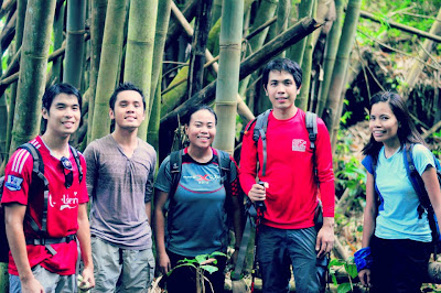
My first hike up Mt. Kalisungan was last December (post here) and I was also with hiker friends, Gideon and Ivan. On our return, we're joined by my friend Arisse, fellow travel blogger Byron and a couple of new found friends - Michael, Ryan, Josh, Terrence, Elijah, Genesis and Christopher.
I remember the hike being just as humid. With my preference to heavily forested trails similar to MakTrav trail, I didn't feel any affinity to Kalisungan at all and it was mainly for the awesome company and the chance to go hiking again that I returned.
|
 |
| That's Mt. Atimla in front. |
 | ||||
It was quite a challenge but I enjoyed navigating around this grassy section.
After the grassy section, we reached a trail covered with trees, some are fruit bearing which meant the presence of red ants. Though we had to be careful to avoid being bitten, I had a grand time ogling at the trees.
3.5 hours later, we arrived at the peak of Mt. Atimla. Apart from other mountains, there isn't much to see. The true reward was the experience and the trails we passed. We witnessed several cows charging off as we entered their grazing area. Here, we stopped for lunch under a tree and a much needed rest.
Our plan was to go down via San Pablo, Laguna which was estimated to take 5 hours. However, it seemed to be meant for a return visit as we missed a turn after the bamboo forest and ended going down via Brgy. Curba, a housing project in Calauan, Laguna. The trail down is relatively easy, taking less than two hours, but as it was already past noon, sun bore down hard against our skin. Still, the view on the way down was entertaining.
It was 2:40 PM when we stopped at a store in the village to grab some refreshments. From here, we took a tricycle back to Barangay Lamot 2 where we were able to take a bath before the long bus ride back to Manila.
Travel Notes :
- A copy of an itinerary to Mt. Kalisungan can be found via Pinoy Mountaineer. (Click here for his account of our hike )
- Expect a hot hike so bring appropriate water supply as there are no water sources along the way. I brought 4 liters.
- To get to Mt. Kalisungan's jump-off from Manila, take a bus bound for Sta. Cruz from the HM Terminal in Cubao. First trip departs at 3:30 AM (124 Pesos (one way), 2.5 hours travel time. After passing the welcome signage of Victoria, Laguna, you will find a junction on the right side displayed with gigantic duck statues. Take a tricycle to the barangay hall of Brgy. Lamot 2 to register (50 Pesos/trike). You can walk or take another tricycle to the jump-off.
- Mountain Guide : Kuya Bino - (+63-909-297-1437). The guide fee is 400 pesos per day for Kalisungan only. Inquire for the cost if traversing to Mt. Atimla. He can also guide you to another nearby peak in San Pablo, Mt. Mabilog.
- You can take a bath at the enormous house of Kuya Bino's friend for 20 Pesos/head. They have a nice bathroom. :)
- After the hike, you can dine at one of the restaurants across the duck junction located along the main highway. This is also where buses to Alabang, Buendia and Cubao pass by. Meals cost less than 100 Pesos/head.
Thanks to Gid for
gathering everyone for a hike definitely fitting for labor day and for Kuya
Bino for guiding us. Til our next hike
everyone! :)
|


